Geo
Advertisement

LimitState:GEO v.2.0.6
LimitState:GEO is the revolutionary geotechnical stability analysis software that can be used to rapidly determine the critical failure mechanism and margin of safety for any type of problem, including those involving: * slope stability * retain
Advertisement
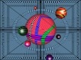
Geo Gizmo 3D Screensaver v.1.0
Welcome to the nanoworld of the Pixel Paradox universe of 2099 AD. Geo Gizmo is a pollution-free nanodevice that acts as a perpetual-motion machine to generate electricity from artificial gravitons in motion above a quantum energy plate,
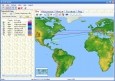
GEO Spider
Now you can trace your network activity on world map. GEO Spider helps you to trace, identify and monitor your network activity on world map. You can trace any website or IP address. Whois reports give to you more info about site, host, domain, ip
Geo Data International Streets
For many countries street coordinates are present with coverage degrees of 100 percent. The geo data offered here are in high-precision quality and are present in several coordinate and reference systems (Geographic, UTM / WGS84, ETRS89). Street
Geo Data International Houses
For many countries house coordinates are present with coverage degrees of 100 percent. The geo data offered here are in high-precision quality and are present in several coordinate and reference systems (Geographic, UTM / WGS84, ETRS89). House Coordinates
Geo Data German Houses
For the area of the Federal Republic of Germany more than 19 million House Coordinates with a coverage of 100% are available. The geo data offered here are in high-precision quality and are present in several coordinate and reference systems.

Geo Data Germany v.15.02
The database contain geodata of the Federal Republic of Germany with geo referenced towns, municipalities, town quarters, administrative units, postal codes, telephone preselections, nature areas, landscapes, climatic zones for proximity searches ec.
C-GEO v.8.4.7.5
If you need to import survey data from your geodetic instruments, then C-Geo is the application to do just that. You can also edit vector and raster maps as this application is able to perform CAD functions as well.
Geo.De.Sy v.1.0.0.10
Geo.De.Sy is a complete drawing environment with survey utilities free for the customers of IQSoft and CivilShop.
A1 Geo-Fit v.1.0.001
The A1 Geo-Fit Game Pack is a collection of three Windows 95 games that are somewhat similar to Tetris. The difference being, that the Tetris squares are divided up into triangles.

Geo data German Streets (English) v.1.00
For the area of the Federal Republic of Germany more than 2,7 million street coordinates with a coverage of 100% are available. The geo data offered here are in high-precision quality and are present in different coordinate and reference systems.